Sample Chapter
Mounds Indiana State Park
Geology of Mounds State Park
The terrain of central and northern Indiana was principally shaped by the glaciers that covered Indiana many thousands of years ago. The central portion of the state features a type of landscape known as the Tipton Till.
Tipton Till
The glaciers’ presence created the two basic landscapes we find today in Indiana. The northern two thirds of the state that the glaciers covered consists of a flat landscape that geologist refer to as the Tipton Till Plain covering the bedrock. As the glaciers advanced and retreated over the eons, they carried dirt, rocks, and other debris with them. When the last glaciers melted, they dropped this dirt and rock mixture right where they were. Geologists refer to four basic types of deposits left by the glaciers as till, outwash, Lacustrine and Silt.
The Four Types
Sand, silt, and clay combined with gravel and boulders are the main components of glacial till. Till was deposited directly by the glacier and has remained largely in the same location. As the glaciers melted, the meltwater formed layers of outwash. Heavier components like gravel and rock were deposited first. The silt, sand and clay particles were carried greater distances by the flowing melt water. The glaciers had carved out depressions in the landscape, which formed the many lakes found in northern Indiana. The silt deposited at the bottoms of these lakes are called Lacustrine. Winds carried the finer materials, called silt, and deposited them further away. These silt layers, called loess, were blown mostly from the Wabash and White River valleys. Near the river valleys this loess sometimes formed thick layers.
Southern Indiana
The southern one third of the state has never, as far as geologists can tell, been covered by glaciers. This region has some of Indiana’s most ancient soils and terrain. Most of the state’s bedrock layer consists of limestone, dolostone, sandstone, and shale. Much of southern Indiana is underlaid with limestone. Much of the southern area consists of Karst landscape. In this type of landscape acidic groundwater flows through the limestone bedrock, dissolving it. This action over time creates sinkholes in the surface, underground caverns and disappearing streams. One predominant feature of south-central Indiana is the Knobstone Escarpment
Knobstone Escarpment
Geologists call the knobs the Knobstone Escarpment. They include some of Indiana’s most rugged terrain. It stretches from Brown County State Park in the north to the Ohio River. Elevations range from 360 feet near the mouth of the Wabash River to Weed Patch Hill, which has an elevation of 1,056 feet above sea level. This hill is in Brown County State Park and is the third highest area in Indiana.
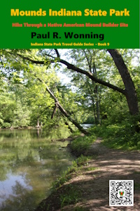
Mounds State Park
The mounds located in the park are more of an historic structure than geologic, however they are the most interesting feature in the park. The builders constructed them on a high bank about 85 feet above the White River. Glacial till forms the surface of the ground, however a 25 – 30-foot layer of gravel underlies this, which is in turn underlain by another layer of glacial till that appears to extend down to the river’s level. Northwest of the biggest mound a series of springs emanate from the base of the gravel layer and flow down to the river. The builders may have chosen the site based on the existence of these springs, as they would have provided a water source.
Top of Page
Mossy Feet Books on Social Media
Twitter
Linkedin
YouTube
Pinterest
Online Sources for Mossy Feet Books
Paul Wonning’s Books on Amazon Page
Paul Wonning’s Books on Scribd Page
Paul Wonning’s Books on Apple
Paul Wonning’s Books on Kobo
Paul Wonning’s Books on Barnes and Noble
Paul Wonning’s Books on 24 Symbols
Paul Wonning’s Books on Google Play
Paul Wonning’s Books on Indigo
Paul Wonning’s Books on Playster
Paul Wonning’s Books on OverDrive
Search Paul Wonning on Ingrams
Table of Contents
© 2024 Paul Wonning
