The Covered Bridges of Southeastern Indiana
Today we will visit the 7 covered bridges in southeastern Indiana.
From the Book:
Southeast Indiana Day Trips
Transcript:
Greetings, today we will visit the 7 covered bridges in southeastern Indiana.
Before getting started, I would encourage you to subscribe to the Mossy Feet Books You Tube channel for more great content. I also entreat you to visit my website, http://www.mossyfeetbooks.com. There you will find sample chapters, podcasts, a slew of content and links to where you can buy my books. While visiting the web site you can subscribe to it and receive email notifications of when I publish a new book or other content, like this video and podcast. You can also subscribe to the Mossy Feet Books You Tube Channel to ensure you do not miss any of my content. This episode is based on my book, Southeast Indiana Road Trips. The book is the first book in the 9 volume Road Trip Indiana Series. The books include all of the historical markers, as of 2022, in Indiana with the text and back story. The books also include a nearly complete listing of virtually every tourism destination in the state. The destinations include parks, museums, drive in theatres, bowling alleys, wineries and much, much more.
You can find my books locally at the Walnut Street Variety Shop in Batesville, Indiana.
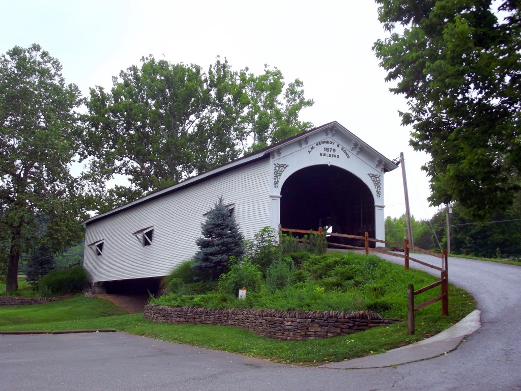
Guilford Covered Bridge
Guilford has the last remaining covered bridge in Dearborn County, constructed by noted bridge builder Archibald M. Kennedy & Sons of Rushville. Mr. Kennedy was hired by the County Commissioners in 1879 to construct the 101 foot long bridge spanning East Fork Tanners Creek. Because the bridge was to be torn down and replaced by a concrete bridge in 1961 the people of the county banded together to save the old structure. The populace of Guilford raised the funds needed to tear it down and move it to its current location, in the Guilford Covered Bridge Park, at the intersection of Indiana State Road 1 and York Ridge Road. An arsonist damaged the bridge in 1993, locals restored the bridge in 1997. Visitors to the park drive through the bridge as they enter the park.
Archibald Kennedy (August 25, 1818 – June 3, 1897)
A native of Guilford County, North Carolina, he was the son of E. L. Kennedy and Martha Kennedy. The family moved to Fayette County, Indiana in 1818. He started working as a carpenter in 1841 and started building covered bridges as a side business in 1853. his first bridge was a two span bridge over the east fork of the Whitewater River in Franklin County. Archibald showed prowess as a bridge builder and this soon became his chief occupation. He passed the bridge building buisness on to his sons who in turn passed it on to their sons. The family bridge building business lasted three generations and during that time they built at least fifty-eight bridges.
Stockheughter Covered Bridge
Constructed by the Smith Bridge Company of Toledo, Ohio in 1887, the Stockheughter Covered Bridge carries Enochsburg Road over Salt Creek in Franklin County. The Howe through truss bridge is 102 feet long, 15 feet wide with a vertical clearance of 14 feet. Rehabilitated in 2009, the National Register of Historic Places listed the bridge on March 20, 2002. Also called the Enochsburg Covered Bridge, the bridge is in Ray Township.
Salt Creek
Length in Decatur County – About 7 miles
Salt Creek rises in Decatur County a short distance northeast of the intersection of County Roads 600E and 100N. It flows generally southwest crossing County Roads 650E, 850E, 150N, 50N, East Base Road before exiting into Franklin County just north of Interstate 74.
Historic bridges crossing Salt Creek include:
Stockheughter Covered Bridge
Fork Salt Creek 150N Bridge
Salt Creek 50N Bridge
Volk Ford Bridge
Length in Franklin County – About 16 Miles
Salt Creek crosses Enochsburg road, passing under the Stockheuger Covered Bridge. After traveling through mostly farmland and forest, it crosses Hamburg Road, Forest Road, Rail Fence Road, Bullfork Road and Indiana State Road 229 before emptyiing into the Whitewater River just west of Metamora.
Snow Hill Covered Bridge
Located on Snow Hill Road in Franklin County the bridge carries Snow Hill Road over Johnson Fork creek near Rockdale, Indiana. Constructed in 1894 – 1895 the bridge’s builders were John H. Horn and William H. Butts. The bridge provided an important passageway for Franklin County farmers wanting to access the Cincinnati Ohio. The bridge was abandoned in 1986 and restored by the community in 1987. The bridges name honors Revolutionary War veteran Lemuel Snow.
Lemuel Snow (December 7, 1759 – September 3, 1824)
A native of Barnstable, Massachusetts born to Lemuel Snow, Sr. and Mary Snow. He passed away on 3 Sep 1824 in Snow Hill, Franklin County Indiana. he and his wife Lydia Hodges Snow had fourteen children.
Lemuel Snow enlisted in the Continental Army at sixteen years old in Boston, Massachusetts. He served during the entire conflict. He was at Valley Forge, and witnessed Major Andre’s execution. he was with the army when the British evacuated it. He was with the Army in Newburgh when General George Washington dissolved the army.
Busching Covered Bridge
The Busching Covered Bridge is located just off US 50 on the entrance road to Versailles State Park. The Busching Covered Bridge crosses Laughery Creek just below the dam for Versailles Lake within the park. The Busching Covered Bridge is within the boundaries of Versailles State Park, but is the property of Ripley County. It is active and open to both automobile and pedestrian traffic.
Busching Covered Bridge was constructed in 1885 using a type of construction known as Howe truss. Busching Covered Bridge is 176 feet long. It connects the entrance road to Versailles State Park with downtown Versailles via County Road 25S, also known as Perry Street. It is active and open to both automobile and pedestrian traffic.
Otter Creek Covered Bridge
Otter Creek Bridge, near Holton, was built in 1884. The bridge is listed on the Ripley County Map. This Holton Covered Bridge, also known as the Otter Creek Covered Bridge, crosses Otter Creek in Ripley County. This single span Howe Truss structure has a length of 112 feet, or 120 feet including the 4-foot overhang at each end, with a portal clearance 15 feet 6 inches wide by 12 feet 6 inches high. Built in 1884 by Thomas A. Hardman, the road bypassed this structure in 1996. Holton Covered Bridge is listed in the 1989 “World Guide to Covered Bridges,” published by The National Society for the Preservation of Covered Bridges, Inc., as #14-69-02 … In the February 1941 “Indiana History Bulletin” Robert B. Yule and Richard C. Smith assigned the designation “ep” to this Covered Timber Bridge located in Section 4, Township 7 North, and Range 10 East, 1-1/2 miles northwest of Holton. Contact the Ripley County Tourism Bureau for more information 812-689-7431.
Westport Covered Bridge
Located east of Westport, Indiana near County Road 1100 S, the Westport Covered Bridge spans Sand Creek. Constructed by covered bridge builder A. M. Kennedy in 1880, the single span, Burr Arch bridge is 130′ long, 15′ wide and 13′ high. The bridge carried traffic until 1973 when County Road 1100S was rerouted and a new bridge built. The Decatur County Historical Society restored the bridge. A section of the old road remains and the bridge is open to pedestrian traffic. It is apparently the only covered bridge built in Decatur County.
Scipio Covered Bridge, North Vernon Indiana
Scipio Covered Bridge
The Scipio Covered Bridge is a Howe truss structure was built in 1886 and is approximately 156 feet in length. It was built by the Smith Bridge Company and is said to be one of the first and longest spans to be built without a center support.
Crossing Sand Creek, this bridge is located on the north edge of Scipio on 575 W and can be seen from Highway 7. The Scipio Covered Bridge is listed as #14-40-01 i
James Covered Bridge
The James Covered Bridge was built in 1887 by Daniel Baron. It is located on County Road 650 S about a half mile east of State Highway 3 in Jennings County. The single span Howe Truss bridge is 140 feet long, fourteen feet high and sixteen feet wide. It crosses Graham Creek. The bridge received the name from Thomas S. James, who owned the property it was built on. Local residents also refer to it as the Kissing Bridge, as many of James’ children courted their spouses on the bridge and left their names carved on the wooden trusses inside.
165 nearby residents filed a request with the county commissioners to build a bridge over Graham Creek. They wanted to make it easier for them to transport their products to the railway for shipping to markets. County commissioners John F. Hayden, Eli Wells, and James McManaman filed a request for the bridge to be built at the James Ford on March 26, 1887. The Barron & Hole Company began building the bridge in the summer of 1887. The work took about 5 weeks to complete.
The bridge is listed as #14-40-02 in the 1989 World Guide of bridges.
The episode is based upon my book, Southeast Indiana Day Trips, available on the web site, http://www.mossyfeetbooks.com. The book is the first book in the 9 volume Road Trip Indiana Series. The books includes information about the parks, museums, historic sites and many other day trip destination across the state. I encourage you to visit the web site and subscribe to it.
I hope you enjoyed this podcast and thank you for listening.
