Indiana’s Pivot Point
Today I will discuss the Pivot, or Initial Point in Indiana.
From the Book
South Central Indiana Day Trips
Transcript:
Greetings, Today I will discuss the Pivot, or Initial Point in Indiana.
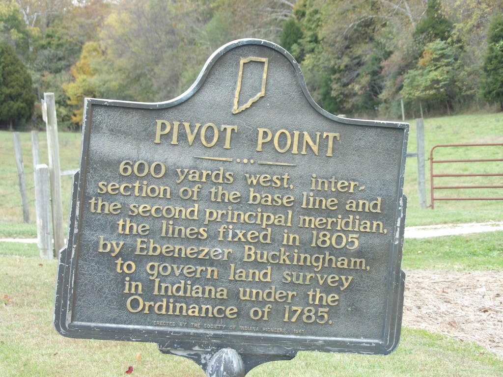
What is the Pivot Point, you ask? Well, it is the initial point of all land surveys in Indiana. The point was established by a surveyor team led by Ebenezer Buckingham on September 1, 1805. I did visit the site in the summer of 2025, however I did not walk back to the actual stone marker, as it is on private land. An historical marker near the road is about 600 yards east of the stone pillar.
Before getting started, I would encourage you to subscribe to the Mossy Feet Books You Tube channel for more great content. If you like my videos, please hit the “Like,” button. The more likes I get the more You Tube will show it to other people, allowing me to grow the channel. I also entreat you to visit my website, http://www.mossyfeetbooks.com. There you will find sample chapters, podcasts, a slew of content and links to where you can buy my books. While visiting the web site you can subscribe to it and receive email notifications of when I publish a new book or other content, like this video and podcast. This episode is based on my book, South Central Indiana Road Trips.
The historical marker is located at the intersection of Indiana State Road 37 and Pivot Point Road, 6.5 miles south of Paoli, 0.5 mile south of Pine Valley & County Road 550 S in Orange County.
The Pivot, or Initial Point marks the point at which legal land descriptions in the Northwest Territory, and Indiana, begin. This point, established by a surveyor team headed by U. S. Deputy Surveyor Ebenezer Buckingham on September 1, 1805.
Beginning Point of the U.S. Public Land Survey
In Ohio an historical marks the point where surveyors established the Beginning Point of the U.S. Public Land Survey in 1785. This point is at the three way intersection formed by the three states of Ohio, Pennsylvania and Virginia (Now West Virginia). It is on the north side of the Ohio River. The commemorative site is located about 2 miles east of the center of East Liverpool, Ohio at the intersection of Ohio State Route 39 and Pennsylvania Route 68.
The First and Second Meridian
A meridian is an east/west surveyor line established to mark boundaries. Meridians are about sixty nautical miles, or about 69.04 miles, apart. The distance is not exact, because the distance is measured at the equator and gradually diminishes as it moves north or south along the poles. The first meridian of the Northwest Territory is the current boundary between Indiana and Ohio.
The Base Line
Working in deep fores under highly primitive conditions, the crew established the First and Second Meridians based upon the beginning point of the US Land Survey established in 1785. After establishing the First and Second Meridian, Buckingham established the base line at 38 28′ 20″ north latitude. Once he had these lines established, the intersection of these lines became the Pivot Point, or Initial Point.
Land Divisions
The meridians and baselines form the basis for the way surveyors divide land in Indiana. Called the grid system, Indiana was the first state laid out with this system. The area around Vincennes does not match up because much of that land was laid out before the the surveyors laid out the grid. Keen map readers will note that all the meridians do not go north exactly north and south. This is because occasionally surveyors have to correct for the narrowing that occurs as the lines move north of the equator. The basic division of the grid is the township. A township is about six miles square. The next division is the section, which is about one mile square, thus there are thirty-six sections in a township. Surveyors next divide each section into quarters which are about 160 acres. Each section will have four quarters. Meridians of longitude are numbered from 0 to 180 E and from 0 to 180 W of the prime meridian, the meridian passing through Greenwich, England. Degrees and Minutes. The distance between degrees of longitude is about 60 nautical miles at the equator. A nautical mile is about 69.04 miles. Thomas Jefferson, working with others, devised this system in 1784. The Pivot Point also is the starting point for almost all land surveys further west.
This was very dangerous work and two men died during the survey. David Sanford died of malaria, and Ziba Foote drowned in a swamp.
Ebenezer Buckingham (February 9, 1778 – August 21, 1832)
The son of Ebenezer Buckingham and Esther Bradley Buckingham, Ebenezer was native to Connecticut. Buckingham learned the surveyor trade and migrated to the Northwest Territory in 1797. Surveyor General Rufus Putnam appointed him as Deputy Surveyor. Buckingham surveyed much of the land in Ohio, finishing there by 1802. He remained in the Ohio River Valley, settling in Zanesville, Ohio. He married General Putnam’s daughter, Catherine. They would have one daughter. Catherine died in 1808 and Buckingham married Sarah, who died in 1815. He married a third time, to Eunice Hale. In addition to surveying, Buckingham ran a general store and warehouse in Zanesville. He continued surveying, platting many towns and did later work in the Indiana Territory. Buckingham also served two terms as an Ohio State Senator. He died while working on a bridge across the Ohio River when a temporary support collapsed.
The episode is based upon my book, South Central Indiana Road Trips, available on the web site, http://www.mossyfeetbooks.com. The book is the first book in the 9 volume Road Trip Indiana Series. The books include all the historical markers, as of 2022, in Indiana with the text and back story. The books also include a nearly complete listing of virtually every tourism destination in the state. The destinations include parks, museums, drive in theaters, bowling alleys, wineries and much, much more. I encourage you to visit the web site and subscribe to it.
You can find my books locally at the Walnut Street Variety Shop in Batesville, Indiana.
I hope you enjoyed this podcast and thank you for listening.
