In the Book:
Southeast Indiana Day Trips
Southeast Indiana Interesting Places
Related Books
| Clifty Falls State Park | Short History of Public Parks – Indiana Edition | The Ultimate Indiana Day Trip Travel Guide | |
| Contact Author | Other Books in Series | Subscribe to the Page |
Transcript
Greetings, today I want to talk about some of the interesting historical places of Southeastern Indiana. I will use the historical markers located around the region as a reference point. My book, Southeast Indiana Day Trips from my Road Trip Indiana Series includes every historical marker installed by the Indiana Historical Bureau in the region. In the book, I include the text of the marker as well as some background information to give the marker more context. Historical markers, ignored by many, can give some interesting insights into the events, people and places of a city, town or village. Many of the topics of the markers are not well known.

Lewis And Clark Expedition
We will begin our tour in Clark County at the Falls of the Ohio State Park and the beginning of the Lewis & Clark Expedition 1803-1806
The marker is located at 1200 South Harrison Street, Clarksville. (Clark County, Indiana)
Marker Text:
Near this site on October 26, 1803, Meriwether Lewis and William Clark with the nucleus of the Corps of Discovery together set off down the Ohio River on their epic journey to explore the Louisiana Purchase and Pacific Northwest.
Lewis And Clark Expedition 1803-1806
William Clark lived with his brother George Rogers Clark in his cabin near the Ohio River when he received the letter from Meriwether Lewis requesting that he become co-commander of the expedition into the vast Louisiana Territory. The cabin became the base camp for Lewis and Clark as they organized the expedition. the Corps of Discovery breathed into life in the cabin as the men recruited men from Indiana, Kentucky and Virginia to make the historic journey west.
Meriwether Lewis arrived at the Falls of the Ohio on October 14, 1803. The Clark Homesite is located within the bounds of Falls of the Ohio State Park in Clarksville, Indiana. The Historic Marker is near the cabin where the men planned the expedition.
President Thomas Jefferson requested that Congress fund and expedition into his newly acquired territory. His instructions to Lewis and Clark were, “The object of your mission is to explore the Missouri River, & such principle stream of it, as, by its course and communication with the waters of the Pacific ocean, whether the Columbia, Oregon, Colorado or any other river may offer the most direct & practicable water communication across this continent for the purpose of commerce.” He also wanted to establish the new republic’s presence in the vast territory. France, Great Britain and Spain all had immense interest in the region and Jefferson wanted to make the United States claim valid with this exploratory mission. Other goals included discovering the sort of natural resources the region had and making contact with the various native tribes that lived there. It was also his hope that they would find a water route across the continent.
Lewis had served President Jefferson as his personal secretary. As such, he gained access to Jefferson’s vast library to study the maps, books and other information Jefferson had acquired. He consulted with Jefferson and gleaned whatever scientific information he needed for the expedition. He studied medicine for a time with noted physician Benjamin Rush. The President also asked astronomer Andrew Ellicott to teach Lewis how to use various navigational aids like the sextant. Jefferson chose Lewis because, in his words, “It was impossible to find a character who to a complete science in botany, natural history, mineralogy & astronomy, joined the firmness of constitution & character, prudence, habits adapted to the woods & a familiarity with the Indian manners and character, requisite for this undertaking. All the latter qualifications Capt. Lewis has.” Lewis chose Clark for his draftsman and frontiersman skills. The men that made up the expedition were all volunteers, chosen for their frontier and survival skills. They departed from the Falls of the Ohio on October 26, 1803. They would be gone for three years, returning with a vast collection of scientific information, maps, charts and a trove of other information about the Louisiana Territory.
Nearby we find the George Rogers Clark Homesite, where William Clark lived with his also famous brother, George.
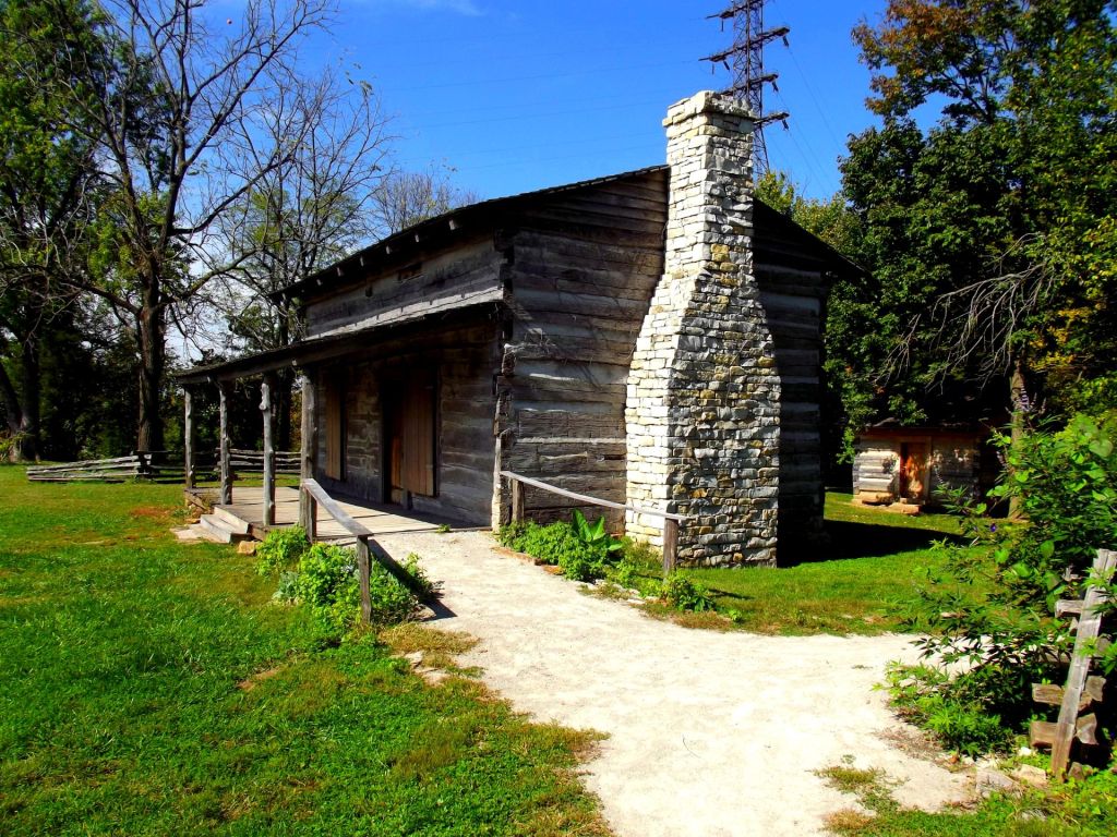
George Rogers Clark Home Site
Revolutionary War Hero General George Rogers Clark settled on this beautiful spot overlooking the grand Ohio River. General Clark’s fame came from his exploits during the winter of 1778 during which he captured the three British posts in the Illinois country, Vincennes, Cahokia and Kaskaskia. This courageous expedition, composed of 175 men, took these posts without firing a shot, thus securing what would become the Northwest Territory from the British. Congress carved six states from this immense territory; Indiana, Illinois, Michigan, Wisconsin, Minnesota and Ohio. General Clark borrowed the money to fund the expedition. The United States Government never properly compensated him for his exploits and he spent most of his last days dealing with financial difficulties.
For his services, the State of Virginia awarded General Clark 150,000 acres, called the Clark Grant. This grant makes up most of current Clark County. Clark built a cabin and a gristmill on the spot occupied by the replica and lived there until 1809, when he had a stroke and fell into the fireplace, burning his leg. The leg needed amputation so he could no longer operate the mill. He moved to live with his brother-in-law in Kentucky, dying in 1818 after suffering another stroke.
The cabin on this spot is not the original cabin. There are no known drawings of that cabin, destroyed in 1854. This one comes from Ripley County, Indiana near the town of Osgood. The State of Indiana moved it here in 2001,
The smaller cabin is also a replica of the cabin occupied by Clark’s servants, the McGee family. Technically slavery was illegal in the Northwest Territory so many slaves that lived there became free when the Northwest Ordinance became law. Many, lacking money to buy land, signed indentured servants agreements with their former masters. Their masters granted freedom and a tract of land to them as payment after a set period of servitude.
Interpretive Panels Describe the Gathering of the Corps of Discovery
William Clark, George Rogers Clark’s younger brother, occupied the cabin with his brother. He kept up correspondence with President Thomas Jefferson, with whom both he and his brother George were friends. In 1803, he received a letter from the President requesting him to form up a company to explore the vast new acquisition, the Louisiana Territory that Jefferson had purchased from France in 1803. The cabin thus became a staging point for the Corps of Discovery. The expedition, now known as the Lewis and Clark Expedition, launched on the nearby river.
The Department of Natural Resources has erected several interpretative plaques outlining the beginnings of this voyage and the men that took part in it.
Overlooking the Majestic Ohio River
Visitors, during the time the park is open, can browse through the cabins and meander through the grounds. There are picnic tables allowing the visitor to gaze out over the waters of the Ohio River as they enjoy their lunch.
Beginning the Lewis and Clark Expedition
The area is ripe with history as the final home of an American Revolutionary War hero, sometimes called the “Conqueror of the Northwest” General George Rogers Clark and his famous brother William Clark, one of the leaders of the Lewis and Clark Expedition.
For more information about the Clark Homesite, visit
George Rogers Clark Homesite
1102 W. Harrison Ave.
Clarksville, IN.
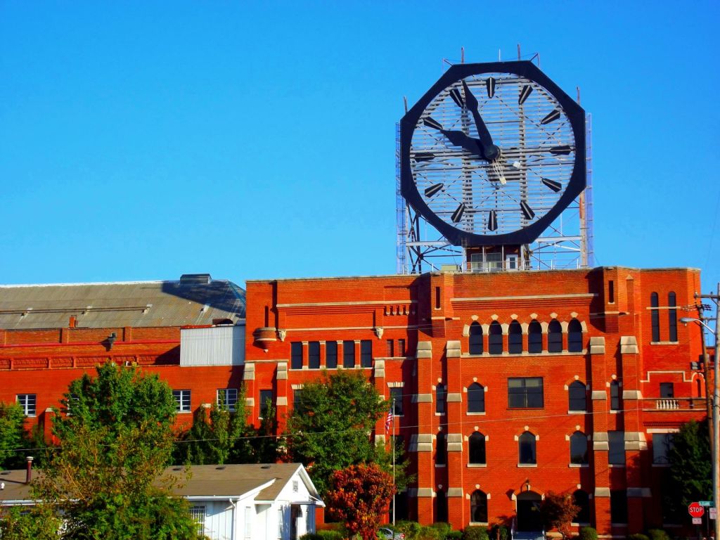
Colgate Clock.
Another popular Jeffersonvill attraction is the Colgate Clock.
The Colgate Clock is the second largest timepiece in the world, exceeding London’s Big Ben. Measuring 40 feet in diameter with hands of 16 and 20 1/2 feet respectively, the Colgate Clock has been a major Southern Indiana landmark for nearly seven decades, since it was first illuminated on November 17, 1924.
The Seth Thomas Company constructed the Colgate Clock. It faces the Ohio River and can be observed from Louisville, Kentucky. The clock is a movie star, as it appears in the movie The Insider.
Big Four Walking Bridge
Big 4 Station Park, located near the Colgate Clock at 1304 Mulberry Street in Jeffersonville, we find the Big Four Walking Bridge that leads to Louisville across the Ohio River
The Big Four Railroad was formed on June 30, 1889, by the merger of the merger of the Cleveland, Columbus, Cincinnati and Indianapolis Railway, the Cincinnati, Indianapolis, St. Louis and Chicago Railway rail companies, the Indianapolis and St. Louis Railways, the company bought the Indiana, Bloomington and Western Railway in 1890. The New York Central acquired the line in 1906; but ran it as a separate entity until 1930. In 1925 the Big Four operated 2,391 route-miles and 4,608 track-miles. It carried 8180 million net ton-miles of revenue freight and 488 million passenger-miles.
In February 2011 Indiana and Kentucky commenced a joint venture to convert the former railroad bridge into a pedestrian bridge that connected the two cities.
Constructed in 1895, the six-span former railroad truss bridge carried trains of the Big Four Railroad across the river. The Kentucky side opened on February 7, 2013. A year later the Jeffersonville ramp opened on May 20, 2014. The bridge connects Waterfront Park in Louisville with the Big 4 Station Park in Jeffersonville. Hikers and bicyclists can enjoy scenic views of the Ohio River on the mile-long route.

Canal Junction
At the NW corner of Whitewater River bridge at Campbell & State Streets across railroad tracks, south side of West Harrison. (Dearborn County, Indiana) From Lawrenceburg, take I-275 east towards I-74, then west toward Indianapolis. Use Exit 3 and turn right on Harrison Avenue. At the intersection of State Harrison Avenue and State Street, turn left. Campbell Road is less than a mile away on the left to the marker that note the location of the Canal Junction.
Marker Text:
Side one:
The Whitewater Canal and the Cincinnati and Whitewater Canal joined in Harrison to provide better access to Cincinnati markets and Ohio River. Indiana Internal Improvement Act 1836 authorized Whitewater Canal; completed from Brookville to Lawrenceburg 1839. Nearby Dam No. 1 on Whitewater River created a pool for canal boats to cross the river.
Side Two:
Cincinnati and Whitewater Canal incorporated by Ohio General Assembly 1837. Completed seven miles from Harrison (now West Harrison), Indiana to Dry Fork Creek, Ohio 1840. Twenty-five mile canal opened 1843 when 1,782 foot tunnel completed at Cleves, Ohio. Traffic diverted to Cincinnati on this interstate transportation link diminished Lawrenceburg’s importance as a market.
Canals reigned supreme during the early part of the Nineteenth Century before the advent of the railroads. They provided a cheap, fast means of transporting goods overland. They had grave disadvantages, though. They were expensive to build and maintain. It was only possible to construct them in favorable terrain. Indiana and Ohio both embarked on canal building programs and managed to link their systems here, at the junction of the Cincinnati and Whitewater Canal and the Whitewater Canal.
Whitewater Canal
The Whitewater Canal’s construction lasted from 1836 to 1847. During this time, there were many starts, pauses as the State of Indiana ran out of money, and the various private companies charged with completing also ran into financial difficulties. After completion, it connected Hagerstown, Indiana with Cincinnati, Ohio seventy-six miles to the south. The canal provided a quick, convenient way for farmers to transport their goods to market in the cities. Before the canal a farmer would need several days travel over deeply rutted roads to take his goods to Cincinnati. The canal proved a difficult construction project. It dropped 491 feet over the distance and needed fifty-six locks and seven dams. Several aqueducts to carry the canal over waterways also needed construction. The canal operated until 1862. The Whitewater Valley Railroad runs a part of the canal as a tourist attraction between Connersville and Metamora Indiana. The train runs alongside the canal and at Metamora visitors can ride a canal boat. The town of Metamora has many small shops and museums. The State of Indiana maintains an operating gristmill in the town.
For more information contact:
Whitewater Valley Railroad
455 Market St,
Connersville, IN 47331
(765) 825-2054
Cincinnati and Whitewater Canal
When Indiana proposed building the Whitewater Canal, Cincinnati merchants persuaded a consortium of private investors and the State of Ohio to fund a spur to connect with it. This fourteen miles spur was constructed between 1839 and 1843. It included a canal tunnel, one of the few constructed in the United States. The canal was eventually abandoned and has silted up over the years from flooding and disuse. The Indianapolis and Cincinnati Railroad purchased the canal in 1862 and used the canal towpath for a rail line. The tunnel, used for a time as a railroad tunnel, still exists and is on the National Register of Historic Places. President William Henry Harrison owned part of the land the canal needed and donated some land towards it. He is buried on a ridge over the tunnel. The Ohio Historical Society has a historical marker near its northern portal.

Whetzel Trace
Whetzel Trace (1818-1823)
Location:
In Franklin County at the the intersection ofMain & Toner Streets, south Laurel we find a marker noting an early road in Indiana, the Whetzel Trace.
Marker Text:
Here Edward Toner founded SOMERSET, 1816, & operated Toner’s Tavern, 1816-1823, from which rallying point pioneers started west on Jacob Whetzel’s Trace to the “New Purchase” of Central Indiana.
Brief History
A man named Jacob Whetzel cut a road through the forest, beginning in 1818. Starting at Toner’s Tavern in current Laurel, Indiana, the road cut into the lands of the New Purchase in central Indiana
Jacob Whetzel (Sep. 16, 1765 – Jul. 2, 1827)
Born near Big Wheeling Creek in West Virginia, Whetzler served in the Indian wars in West Virginia and Ohio, fighting under Generals William Henry Harrison and Arthur St. Clair. After the wars, he, his son Cyrus and four other men he hired cut a trail through the forests. His grave is in MacKenzie Cemetery, in Morgan County.
Edward Toner (April 8, 1783 – February 18, 1867)
Born in Lycoming Co., Pennsylvania to a father who came from Somerset, Ireland during the Revolutionary years, Edward moved to Franklin County, Indiana. Toner and his wife settled in a town named Somerset, a town he founded and named for his father’s Irish home. He established the tavern that served as the trailhead for Whetzler’s Trace.
“New Purchase”
The lands acquired from the Miami tribe by the terms of the Treaty with the Miami, 1818 (Treaty of St. Mary’s), are referred to as the “New Purchase.” Jonathan Jennings, Lewis Cass, and Benjamin Parke acting as representatives of the United States signed a treaty with the Miami nation on October 6, 1818. As per terms of the treaty, the Miami has ceded a vast area in central Indiana to the United States. The United States agreed to pay the Miami tribe fifteen thousand dollars a year, erect a gristmill and one sawmill. They would also provide a blacksmith and pay one hundred sixty bushels of salt a year to the tribe. After the agreement was reached, Whetzler cut the trace into the new lands and founded a small settlement of his own

Little Cedar Grove Baptist Church
At the intersection of US 52 & Little Cedar Road, north side of highway, 3 miles south of Brookville, Mound Haven. (Franklin County, Indiana)we find the Little Cedar Grove Baptist Church.
Marker Text:
Built in 1812, this is the oldest church building still on its original location in the state. Interior shows rifle openings in walls, a balcony and raised pulpit. Burial plot adjoins church.
Brief History
When the New Madrid earthquake struck on December 16, 1811 the Primitive Baptists that made up the congregation of a church organized in 1805 took it as a sign from God that he was displeased with them. When the aftershocks continued into 1812, the people became convinced of it.
The Primitive Baptists
The church’s founders were members of the William Tyner and Abraham Hackleman families. Historical evidence suggests that the men had fought in the British Loyalist Militia during the Revolutionary War. At war’s end, the families were not welcome in their North Carolina community. The families first migrated to Scott County, Kentucky. From Kentucky, the families moved to the Ohio Territory and established the first Baptist church in Ohio. In 1805, they moved once again, this time to an area west of current Brookville, Indiana. They built a log church in 1805 and used that structure until the 1811 earthquake.
The New Church
The earthquake and the aftershocks frightened them and they called a prayer meeting and vowed to build a proper church if God would send no more earthquakes. In 1812 they built the current brick church on the site of the original log church. They completed construction of this church on August 1, 1812. A cemetery with the graves of many of the original settlers adjoins the church. Betsy Hackleman’s grave, wife of Abraham Hackleman, is inside the church, the only grave still intact from the original cemetery. She had died in 1810.
The Franklin County Historical Society now maintains the site and it is open to the public.
Franklin County Historical Society
P.O. Box 342
Brookville, Indiana 47012
http://www.franklincountyhistoricalsociety.com/Welcome.html

Academy of the Immaculate Conception
In the lovely town of Oldenburg in Franklin County we discover a marker noting an early school, the Academy of the Immaculate Conception
Marker Text:
Sisters of Saint Francis
Opened in 1852; enlarged in 1876 and 1901. The Academy Classroom Building and the Auditorium were completed in 1968.
Brief History
From her home in Vienna, Austria, twenty-four year old Mother Teresa Haclkemeier traveled to the hills of Franklin County, Indiana to settle at the town of Oldenburg. During the nine years she ministered to the town she would establish the Sisters of St. Francis of Oldenburg, a school and care for orphans.
Oldenburg, Indiana
German immigrants founded Oldenburg, Indiana in 1837, naming it after their native city in Germany. The first settler, William George, arrived with his brother in 1817. They blazed a trail across the southeastern Indiana forests until they arrived at a site on the East Harvey Branch creek. They settled there and for the next twenty years, little changed other than the trees they felled to clear their fields. The flow of German immigrants from Germany increased during this time and many found their way to the new community guided by Father Joseph Ferneding. Father Ferneding was a traveling Catholic missionary that would cross Ohio River and persuade German families to come to the developing town. Oldenburg was platted in 1837, with room left for the Catholic Church already under construction. The small log church was called St. Mary’s and would form the nucleus of a growing Catholic population that would flavor the town with its unique Germanic culture. That culture lingers into the Twenty-First Century.
Teresa Haclkemeier
Fr. Francis Joseph Rudolf ministered the Oldenburg church and invited Sister Teresa Haclkemeier to come to the community and establish a school to teach and care for the children. A cholera epidemic had ravaged southeast Indiana in 1847, leaving many children as orphans. The young woman responded to the call and traveled alone across the ocean. She traveled from New York via the Erie Canal and the Ohio River. Father Rudulf met her at Lawrenceburg and brought her to Oldenburg. She opened her school in a one-room log cabin at the base of the Oldenburg hill.
Sisters of St. Francis of Oldenburg
Three other young women soon joined her. These were Sister Michaela, Sister Theresa Dreer and Mother Antonia. These women established a boarding school that housed six children and a school that taught twenty. They also founded the Sisters of St. Francis of Oldenburg. This Sisterhood established other schools throughout Indiana. The sisters traveled to other towns to teach, returned each spring to their Oldenburg base for spiritual retreat, and continue their training.
Beginnings of the Academy of the Immaculate Conception
By 1851, the Sisters had taken full charge of the school, which had grown to include twenty children. The winter of 1851, the weather had become cold and snowy and it was unsafe for the children to return their homes on remote farmsteads. Five of the children became the first boarding students at the school. The next year the number of boarding students grew to twelve. The tradition of boarding students continued to grow.

Madison Historic District
Madison in Jefferson County is one of Indiana’s oldest cities. Vistors to this charming city will find a marker noting the Madison Historic District at Vaughn Drive & Jefferson Street at Ohio Riverside walk, Madison
Marker Text:
Madison Historic District, listed in National Register, 1973, in over 130 blocks contains hundreds of structures of every type, size, and period, 1812-1920, including many outstanding examples of major 19th century architectural styles. Madison is significant in growth of Indiana historic preservation movement.
Brief History
Formed in 1960, Historic Madison, Inc was a pioneer effort in the movement of small towns acting to preserve their historic heritage. Since Madison is one of the first communities in Indiana settled, the community possessed a rich heritage of historic buildings. The organization conducts many tours and events that present the history of Madison to interested visitors. In addition, Historic Madison features several historic buildings around the town, many of which are open to public. The list of publicly open is below:
Ben Schroeder Saddletree Factory Museum
Costigan House
Dr. Hutchings Office & Hospital
Jefferson County Heritage Center (.org)
Jefferson County Historical Society & Museum
Lanier Mansion
Madison Railroad Station Museum
Sullivan House
More Museums
Lanier- Schofield House
Historic Eleutherian College
African Methodist Episcopal
Jefferson County Historical Society
https://sites.google.com/view/historicmadisoninc
Madison Incline and Cut
At the intersection of 1001 W. Main & McIntire Streets, SW corner of railroad bridge we find what at one time was the steepest railroad incline in the United States.
Marker Text:
Built 1836-1841 as part of Indiana’s 1836 Internal Improvement Act. Measures 7, 012 feet long and elevates 413 feet to achieve a 5.89 percent grade; 500, 000 tons of rock and earth were moved in construction. Still considered to be the steepest standard gauge main track ascended by wheel-adhesion locomotives in the U.S.
Brief History
Construction on the Incline and Cut began on September 16, 1836. The project had its beginnings in the Internal Improvement Act of 1836, which authorized a massive internal works program. Completion o the cut took five years of hard labor by predominantly Irish laborers. The workers moved an estimated 500,000 ton of rock and earth. This included from forty to 125 feet of limestone bedrock. The first train ride up the incline was on November 3, 1841.
Steep Incline
The steepness of the incline was too much for any railroad locomotive at the time, so trains had to be pulled up the incline by teams of horses.
Brough’s Folly
An attempt to lessen the incline began in 1852. John Brough, president of the Madison and Indianapolis Railroad proposed a new route that would enter the Clifty Creek Canyon west of Madison. It would descend on a less steep incline into Madison. The State of Indiana approved the project and Brough started construction. He believed the project would take three months. However, the terrain was difficult and required the construction of two tunnels plus a number of trestles.
Cost and Time Overruns
A year after construction began; the cost of the new route had run over by $115,000. The $300,000 dollar project turned into a 415,000 project and the money ran out. The M & I Railroad had to abandon the project. Visitors to the park can still see some of the trestles constructed during the 1850’s for the rail line.
Visitors to Clifty Falls State Park can see two of the tunnels on Trail 5, as well as some of the trestles.
For more information about Clifty Falls State park, see this link.
Locomotive Reuben Wells
The railroad tried a number of special built locomotives to handle the grade. They finally hit pay dirt with the Reuben Wells, constructed in 1868. It ran regular runs until 1898. After that it served as a back up locomotive until 1903.
Accident
On October 25, 1943 a locomotive went out of control and crashed in downtown Madison. The engineer and conductor of the train were killed. The wrecker train sent to clear the wreckage away also crashed. No one was hurt in that crash. The railroad still serves the Madison Port Authority on an as needed basis. The Madison Heritage Trail follows a portion of the railroad.
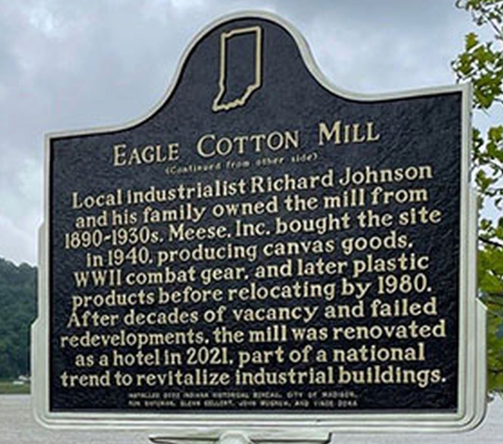
Eagle Cotton Mill
At 108 St. Michaels Ave., Madison (Jefferson County), Indiana 47250, we find an historic site where you can spend a night or two enjoying the area, the Eagle Cotton Mill.
Text
Side One
The Eagle Cotton Mill began production here in 1885, shipping goods such as twine, candle wick, and fabric via the Ohio River to national and international markets. After an economic downturn in the mid-1800s, the mill helped rejuvenate Madison’s river commerce. A major city employer, its largely female workforce led an 1889 strike for better working conditions.
Side Two
Local industrialist Richard Johnson and his family owned the mill from 1890-1930s. Meese, Inc. bought the site in 1940, producing canvas goods, WWII combat gear, and later plastic products before relocating by 1980. After decades of vacancy and failed redevelopments, the mill was renovated as a hotel in 2021, part of a national trend to revitalize industrial buildings.
Robert McKim, John Adams, Charles Cravens, James Hargan, Charles A. Korbly, Charles Alling and S.M. Strader filed paperwork in 1882 to initiate the process of forming a corporation they would call the Eagle Cotton Mills of Madison. They planned to build a cotton mill in Madison with the capacity of producing 11,000 yards of muslin cloth a year. After successfully forming their company, the board of directors next began negotiations to purchase the Eagle and Banner Cotton Mill, located in Pittsburg. This company had been in Pittsburg for almost 50 years. By 1884 the purchase had been completed and the men began finalizing their plans to construct the factory in Madison, Indiana. They hoped to draw many of the skilled workers at the Pittsburg plant to Madison as well as employ hundreds of Madison residents.
The City of Madison agreed to sell the company a tract of land that served as the city’s gravel pit between Church and Baltimore Streets. They awarded a contract to construct the four story 247 x 74 foot building in 90 days. The three lower stories were to be 12 feet high and the fourth floor 14 feet. The construction project would also include a three story picker house, an engine house and boiler house. The J.M&I Railroad Company laid a switch line to the mill and the Edison Electric Light Co. of New York City had installed 312 electric lights. The mill began operations with 300 employees on March 1, 1885.
The picker house was the first destination for cotton bales delivered to a mill for processing. After the cotton arrived workers separated the bugs, twigs, leaves and other debris from the cotton. After cleaning it they fed the cotton into a machine called a breaker lapper which stretched out the cotton to clean it and form it into loose cotton sheets called laps. The process created a great deal of dust, which was a fire hazard. For this reason the picker house was located some distance away from the cotton mill.
The boiler house contained huge, furnaces that workers shoveled coal into to produce the fire that boiled huge boilers filled with water to produce steam that was piped to areas within the mill for heating.
The engine house had a large steam engine that powered the looms and other machinery in the plant.
Working conditions in the plant were harsh, as workers toiled 11 1/2 hours per day, six days a week. The workers went of strike in 1889. demanding 10 hour day. they recieved an 11 hour a day with a 45 minute lunch break. Saturdays were reduced to 9 hours with a 45 minute lunch break.
Steamboats docked at the mills wharf to unload cotton bales and other raw materials and to load finished products. The mill produced
The directors sold the plant to Richard Johnson in 1891. Johnson installed new equipment in 1892 and operated it until 1909, when he passed away. Johnson also owned the Riverside Starch Works. He closed this and established the Johnson Cordage Company in that building. In 1917 the cordage factory burned and Jonson’s sons, who now ran the company, moved the cordage works into the cotton mill. These mill and cordage works operated in the same building until closing in the late 1930’s. Since the building contained more floor space than the mill and cordage factory needed, the company leased the top floor to the Longinni Shoe Company.
A business consortium led by Edwin Meese purchased the building and moved their business into the building. This company produced canvas mail carts, laundry carts, ice cream carts and canvas shipping containers as well as other canvas products. Meese operated his business in the building until moving it to another location in the early 1980’s.
The building, now vacant, changed owners several times over the decade and was the subject of many different renovation plans. All of these plans failed until Riverton LLC, the City of Madison, and the Indiana Economic Development Corporation (IEDC) concluded a plan to turn the property into a boutique hotel. The project broke ground in 2019 and the 85-room hotel opened in June 2021.
Historic Eagle Cotton Mill – Fairfield by Marriott Inn & Suites
108 St. Michaels Avenue
Madison, IN 47250
(812) 274-5900
https://www.facebook.com/Fairfieldmadison/
Michigan Road
In Ripley County we find a marker at the intersection of US Route 50 and Old Michigan Road that notes the importance of Indiana’s first super highway. Title of
Marker Text:
Extending from Michigan City to the Ohio River at Madison. Begun by the state in 1832 with funds obtained from sale of land granted by the Potawatomi Indians. Opened northern part of state to settlers.
Brief History
Michigan Road is one of the oldest roads in Indiana, built in the early 1800’s to connect Madison, Indiana with Michigan City. When the Indiana State Government moved from Corydon, Indiana to Indianapolis, the legislators and governor found themselves in isolation. There were no good roads leading to the new capital city and the White River was not navigable. They sought to rectify this by passing legislation to build the first “superhighway” in the State of Indiana. To accomplish their goal, they needed to negotiate a treaty with the Pottawattamie Indian Tribe and clear a vast swath of trees the length of the state.
Madison
The first settlers began populating the site now known as Madison, Indiana around 1806. The town was incorporated in 1809, seven years before Indiana became a state. It is location along the Ohio River caused it to become an important town in the early state’s history. In 1836 the Madison & Indianapolis Railroad was completed, connecting the growing city with the new state capital. The state’s first major highway was the Michigan Road, commissioned in 1828. Construction began in 1830 and the road was completed in 1837. The Michigan Road, later to become State Road 29, ran from Madison, Indiana to Michigan City on Lake Michigan in the north. It ran through Indianapolis, connecting the state capital to the Ohio River and Lake Michigan. So by the 1840’s, Madison was connected to the northern part of the state by road and rail.
Half of Early Pioneers Used the Road
Over half of the pioneers settling Indiana passed along this road, and this influx of traffic allowed Madison, Indiana to grow. Competing rail lines caused the railroad to fail, and other routes opened up, causing Madison, Indiana to fall in importance while other cities grew. The population maintained itself from the Civil War until the late 1900’s. A program of downtown renewal has resulted in the creation of a vibrant small city along the banks of the Ohio River. The historic downtown has been revitalized, a river walk built along the river and there are exciting events all year, making Madison, Indiana a picturesque and inviting town to visit.
Michigan City
The need for a good harbor on Lake Michigan spurred the development of Michigan City. A real estate developer named Isaac C. Elston purchased 200 acres along the lakeshore in 1830. He recorded the plat in 1833. Michigan City incorporated in 1836. The completion of the Michigan Road in 1837 connected the growing city with Indianapolis and the Ohio River far to the south.
Treaty with the Pottawatomie, 1826
The planned route of the road lay is land still claimed by the Pottawattamie Indian Tribe, of which several hundred still lived in the area. To complete the road, the state needed to conclude a treaty with the tribe. This tribe and the state concluded this treaty on October 16, 1826. By terms of the treaty, the tribe conceded a strip of land 100 feet wide through their lands.
Construction of the Road
The legislation called for a road 100 feet wide, with the center thirty feet to be free of stumps. The state contracted out one-mile long increments of the road to the lowest bidder. The first fifteen miles of road leading from Madison took over a year to build. The road traveled north from Madison to Napoleon, Indiana and on to Indianapolis.
Indiana State Road 29 followed much of the old route, which today has been superseded by several other highways and roads.
US 421 Follows Michigan Road
US Route 421 north of Madison follows some of the route of this early highway, and a section along Big Oaks National Wildlife Refuge follows the original route of this early, historic road as it worked its way north. It begins at an intersection with US 421 about one mile north of the Jefferson County Line. A Morgan’s Raid Marker is just off on the left as the road begins. For the first 5.1 miles, Big Oaks National Wildlife Refuge borders the west side of the road.
Michigan Road crosses US Route 50 about 10.5 miles from its inception on US 421.
Napoleon
Michigan Road ends about 8.8 miles north of US 50 at an intersection just south of Napoleon, Indiana. As it turns just near the northern end, the original route of the road may be seen along the western edge of the cemetery. From Napoleon, the old road follows US 421 to Logansport. From there State Road 25 followed the original route to Rochester, Indiana. U.S. Route 31 followed the original route from Rochester to South Bend, Indiana. State Road 2 and U.S. Route 20 follow the original road from South Bend to Michigan City. Short sections still exist in Indianapolis.
The Michigan Road was an important early conduit of travel and commerce in the State of Indiana’s early history and it still exists in short sections. Another section survives in Decatur and Shelby counties.
Scott County Home
In Scott County we find a marker at 1050 S. Main Street, Scottsburg that notes the location of the Scott County Home
Marker Text:
Side one:
Indiana law in 1831 authorized counties to establish institutions to support and accommodate the poor, carrying out 1816 Constitution provision. First Scott County home built 1861 north of Lexington; closed 1879. County home moved here to frame house on 180 acres. Residents of such asylums could farm and help support the facilities.
Side two:
This brick structure replaced the frame house in 1892. Over time, acreage was reduced. Structure ceased to function as county home 1973. Scott County public services and government offices located here until 1995. Listed in National Register of Historic Places 2000. Property named home of Scott County Heritage Center and Museum 2001.
Currently the home of the Scott County Heritage Center and Museum, the County Home, or Poor Farms as the facilities came to be known, served an important purpose during the times of their use. People who had no family to care for them came to live at the poor farm. These were usually elderly folks who needed a place to live. However, younger people could live there, too. People living there had a task assigned to them on the working, self-sufficient farms.
For more information about the Home or Scott County History contact:
Scott County Heritage Center and Museum
1050 South Main Street
Scottsburg, Indiana 47170
812.752.1050
https://scottcountyheritagemuseum.org/
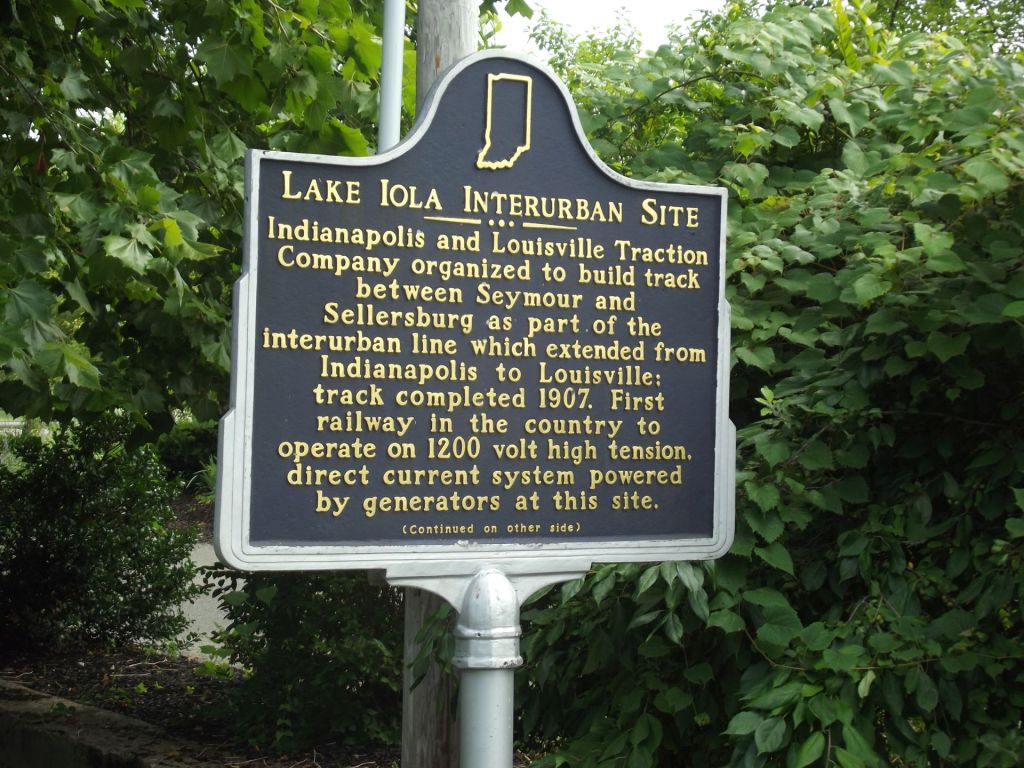
Lake Iola Interurban Site
On the north side of Scottsburg we find the Lake Iola Interurban Site on the East shore of Lake Iola, William H. Graham Park, N. Bond Street, Scottsburg.
Location:
Marker Text:
Side one:
Indianapolis and Louisville Traction Company organized to build track between Seymour and Sellersburg as part of the interurban line which extended from Indianapolis to Louisville; track completed 1907. First railway in the country to operate on 1200 volt high tension, direct current system powered by generators at this site.
Side two:
Car barn and water tower also built on site. Artificial lake–later named Lake Iola–created as water source for power equipment. Indiana Railroad abandoned operation; last train October 31, 1939. Building foundations and some track remain. Land around Lake Iola is now property of Scottsburg, serving the city as park and interpretive center.
The Interurban rail lines of the late Nineteenth and early Twentieth Centuries provided the first mass transit system connecting the rural areas with the cities. In the era before the automobile and paved highways, the interurban lines provided fast, cheap transportation across not just Indiana, but the nation as well. The interurban railways rose in the late 1880’s and reached their prominence by 1925. The rise of the automobile and paved highways started their demise.
An interurban was a rail line that used electricity for power and operated between cities. The 1905 Census definition was “a street railway having more than half its trackage outside municipal limits.” this definition separated an interurban from suburban railroads. Indiana State Senator Charles L. Henry coined the term interurban at the World’s Fair in Chicago in 1893 while
Construction of the track, which paralleled the Pennsylvania Railroad tracks, began in 1895. Completion of the final link between Sellersburg and Seymour, Indiana occurred in 1907. The line offered quick transportation between Louisville and Indianapolis, about three hours from downtown to downtown. Trains bound south were dubbed “Dixie Flyer” and northbound trains “Hoosier Flyer.” The interurban made several stops along the way. Passenger traffic provided the main revenue, but the trains also transported freight. During strawberry time, “Strawberry Specials” took fresh strawberries from Floyd County to Indianapolis and Louisville. The train line had special cattle cars that took cattle directly to the stockyards in downtown Louisville. The line was active until October 31, 1939 when the last train ran.
The historical marker is at William H. Graham Park at Lake Iola, on the northeastern edge of Scottsburg. The park has a walking trail around Lake Iola, picnic shelters and restroom facilities. Visitors will also find a train car parked in a pavilion on display in the park.

Marshfield Train Robbery
Scott County is also the site of one of the earliest train robberies in the United States, the Marshfield Train Robbery. The marker is at the intersection of US 31 & Terrell Road.
Marker Text:
Side one:
One of earliest U.S. train robberies occurred May 22, 1868 at nearby Marshfield, a refueling and watering stop. Engine and express car were detached from Jeffersonville, Madison, and Indianapolis Railroad train and abandoned near Seymour. Notorious Reno Gang took U.S. treasury notes and government bonds from Adams Express Company safes in car.
Side two:
Indiana-based Reno Gang operated after the Civil War during a period of unemployment and lawlessness. Vigilante organizations continued to be active. Pinkerton National Detective Agency investigated Marshfield robbery and apprehended several suspects. Before any were tried, members of Reno Gang were lynched by vigilantes.
Brief History
The town of Marshfield, Indiana was the site of one of the earliest recorded train robberies in the United States. The locally famous Reno gang pulled off the robbery that proved to be the last criminal act by the gang.
Marshfield, Indiana
Platted on May 22, 1857, the founders named the town after Marshfield, Massachusetts. The post office opened on April 6, 1857 and remained until 1989. By the 1860’s the town had grown to include a dry goods store, a hotel, three churches, three saloons, two blacksmith shops, a grain warehouse, a wagon and carriage manufactory, a grocery store, a drug store and three physicians. The Jeffersonville, Madison and Indianapolis Railroad used it as a water stop. The locomotives of that era needed to stop to replenish the water in their boilers every few miles to keep going. The now abandoned town is on US 31 about three miles north of Scottsburg, Indiana
Reno Gang
The Reno Gang operated primarily in the southern Indiana countryside in and around Jackson County. Their repertoire of crime included robbery, arson, bribery, murder and burglary. Their train robbing activities provided a primer for later western outlaws like the James Gang.
The Reno Family
James Reno moved into Indiana from Kentucky in 1813, locating near the small town of Rockford, Indiana. His son, Wilkinson Reno married Julia Ann and had five sons and one daughter. Frank was the oldest, born in 1837, followed by John in 1838, Simeon (“Sim”) in 1843, Clinton in 1847, William in 1848, and Laura, in 1851. The only sibling not involved in the gang was Clint. The parents tried to instill a righteous upbringing by requiring the children to study the bible for hours at a time on Sunday. Four of the sons rebelled, as well as Laura.
Criminal Activities begin
Their criminal activity began with card games they would play with travelers along the road. The children cheated and hoodwinked travelers out of their money. Their activity soon expanded to arson in 1851 when several businesses in Rockford were burned. Everyone suspected the Reno’s, but no one ever filed charges. When the Civil War began, the Reno’s discovered the art of “bounty jumping.” They would enlist in an army unit; collect the bounty, and then desert. Before the end of the war, the Reno’s had recruited other outlaws to come into the area. Using a hotel called the Radar House as a headquarters; the gang planned their criminal activity, which included post office robberies, burglaries and arsons. The authorities arrested them several times, but witnesses never came forward for fear of their lives, so they always released them. There was cause for the witnesses fear, because many who did threaten to testify were murdered. Jackson County had become a nest of crime with county officials either accepting bribes or intimidated into inactivity. A precursor to their famous train robbery occurred on October 6, 1866 when three members of the gang boarded an Ohio & Mississippi train. After the train started, the gang members forced their way into the Adams Express Company car and forced the messenger inside to surrender his keys. The gang members opened a safe, stole the cash and gold inside. They rolled one safe off the back of the train and pulled on the signal rope. The engineer stopped the train. The gang members then pulled on the rope again, signaling the “all clear” message to the engineer. As the train pulled away, the gang made off with the loot. They were unable to open the safe they had rolled off the back.
The Train Robbery
The Marshfield train robbery served as the model for the James Gang and those that came after. It occurred on May 22, 1868. The train had left Jeffersonville, Indiana and reached Marshfield around 11:00 PM. Twelve gang members moved out of the darkness and overpowered the train crew. They uncoupled the train from the locomotive, leaving only the Adams Express coupled to the locomotive. They took the train on towards, ordering the engineer to proceed, at gunpoint. The train continued to Seymour while the outlaws ransacked the car. The Messenger resisted and they threw him from the speeding train. The Messenger survived, though hurt badly. Their efforts paid off when the outlaws found $96,000 in US Government bond, cash and gold. They ordered the engineer to stop in a valley of the Muscatatuck River where other gang members waited with horses. After dividing the loot, the gang took off into the darkness.
Apprehended
Over time, most of the Reno brothers were apprehended. A band of vigilantes in Jeffersonville hanged them on December 12, 1868 as they awaited trail. Legend has it that there is $96,000 in gold, cash and securities still buried somewhere in Jackson County, as the gang members never divulged where they stashed the loot.

Pigeon Roost Massacre Site
Our last destination is the Pigeon Roost Massacre Site at the Entrance to Pigeon Roost State Historic Site, US 31, 5 miles south of Scottsburg. (Scott County, Indiana)
Marker Text:
Side one:
Pigeon Roost, settled 1809 in Clark County, was attacked on September 3, 1812. Over twenty settlers and an unknown number of Indians were killed. Clark County militia unsuccessfully pursued the remaining Indians. That same month Fort Harrison and Fort Wayne were attacked by Indians. The U.S. had declared war on Great Britain, June 18, 1812.
Side two:
The Pigeon Roost raid was part of the ongoing conflict between Indians—influenced by the British—and settlers along the frontier, one of the contributing factors of the War of 1812 in the west. The State of Indiana appropriated $2, 000 for construction of the memorial here, dedicated October 1, 1904. This site became a State Historic Site 1929.
Brief History
The first War of 1812 action in Indiana occurred at the village of Pigeon Roost when native warriors, seeking scalps to claim bounties offered by the British, struck at the village at dusk on September 3, 1812.
The War of 1812
There were many reasons for the American declaration of war on Great Britain on June 18, 1812. The most important ones were Britain’s habit of stopping United States ships on the high seas and impressing sailors into the Royal Navy and other humiliations of US ships. Trade restrictions imposed on the United States by Great Britain during their war with France were another reason. Britain also threatened American western expansion by encouraging the native tribes to attack settlers moving into new areas. They encouraged the attacks by offering bounties on any scalps the natives brought to a British Outpost. The attack at Pigeon Roost was in response to this bounty system.
Pigeon Roost Village
William E. Collings (1758-1828) established the village of Pigeon Roost in 1809. The settlement was in lands still claimed by the Shawnee. There was an Amerindian village a few miles from the new settlement. Most of the settlers came from Kentucky. The village consisted of a line of cabins along the mud road leading to Vienna from Henryville. Vienna and Henryville were the closest blockhouses to Pigeon Roost. The settlers chose the name of Pigeon Roost because large numbers of passenger pigeons inhabited the area.
The Attack
Few men remained in Pigeon Roost at the time of the attack, as most were at Vincennes with William Henry Harrison’s force there. The war party consisted mostly of Shawnees, but some Pottawattamie and Delaware were probably in it as well. Legend says they crossed the White River near Sparksville and proceeded through Vienna without attacking it. There are stories of bad blood between the Collings family and the Shawnee and that is why the natives chose Pigeon Roost. The first settler to sense something was wrong was Jeremiah Payne of Vienna. Upon investigating his cattle lowing, discovered arrows protruding from several of them. He rode to his cabin and took his wife and children to Vienna’s blockhouse, then sped to Pigeon Roost to spread the warning to his brother Elias. Upon arrival at his brother’s cabin, he discovered the dead and scalped bodies of his sister-in-law and their seven children. Elias and a neighbor had been scouring the forest, searching for bee trees and the honey they offered. The attackers went on through the settlement, burning the cabins, killing and scalping anyone they encountered. Many of the settlers managed to escape to the blockhouse at Henryville, but not before the warriors killed over twenty settlers. The survivors buried most of the victims in a mass grave near the site.
Pursuit
Militia units located in Charlestown heard of the attack and set off in pursuit of the war party. They lost the trail near the Muscatatuck River. A band of Indiana Rangers from Washington County led by Captain Henry Dawalt intercepted them at Sand Creek in Bartholomew County. They engaged the party, but failed to stop their escape.
Pigeon Roost Memorial
Scott County maintains the site, a former Indiana State Historic Site. Indiana turned the facility over to Scott County. Scott County has built a log cabin on the site similar to the cabins that would have been there in 2014. The State of Indiana erected a limestone memorial to the victims in 1904. The Memorial is on US 31 just south of Scottsburg, Indiana.
Find out more about these Indiana day trip destinations and many more by purchasing the book Southeast Indiana Day Trips. The book includes location information as well as information state parks, nature preserves, golf courses , wineries, breweries and much, much more. You can find it on my web site, http://www.mossyfeetbooks.com on the Road Trip Indiana category. Just scroll down to categories, click the Road Trip Indiana Series. There are links to Amazon, Barnes and Noble, Google Play and other online book sellers. You may choose to purchase the book in ebook or softbound versions. An audio book version is available on Google Play. There will be one more podcasts in this series covering the court houses in the southeastern part of Indiana. At the conclusion of this series I will compile the episodes into an audio book. The next series will cover Indiana’s role in the Civil War. Listeners may also be interested in my book, The Ultimate Indiana Day Trip Travel Guide. The 747 page book includes a plethora of day trip destination in Indiana. A complete tourism guide the book includes local and state parks, museums, golf courses and much, much more. The book includes information on all of Indiana’s 92 counties. No traveler in Indiana should be without it.
You can also order these books direct from me, the author, on the web page. If you wish me to sign the book, just send me an email to mossyfeetbooks@gmail.com requesting a signed book and instructions on how you want me to address it. Note, if you send me an email, I will add you to my contact list. Readers on the list will receive an email from me announcing when I publish a new book. If you do not want me to add you to the list, tell me and I will not add you. Listeners to this podcast that want email notification of my new releases can just send me an email requesting addition to the list. You can choose to have your name removed at any time. If you browse the web site you will find dozens of sample chapters, one for each of my books. I hope you enjoyed this podcast and thank you for listening.
Indiana Places and History Podcast
Top of Page
Mossy Feet Books on Social Media
Twitter
Linkedin
YouTube
Pinterest
Online Sources for Mossy Feet Books
Paul Wonning’s Books on Amazon Page
Paul Wonning’s Books on Scribd Page
Paul Wonning’s Books on Apple
Paul Wonning’s Books on Kobo
Paul Wonning’s Books on Barnes and Noble
Paul Wonning’s Books on 24 Symbols
Paul Wonning’s Books on Google Play
Paul Wonning’s Books on Indigo
Paul Wonning’s Books on Playster
Paul Wonning’s Books on OverDrive
Search Paul Wonning on Ingrams
Table of Contents
© 2022 Paul Wonning
